
Addanki topographic map
Click on the map to display elevation.
Addanki
Addanki located at 15°49′00″N 79°59′00″E / 15.8167°N 79.9833°E / 15.8167; 79.9833. It has an average elevation of 24 meters (82 ft). It is located between Guntur (70 kilometres (43 mi)) and Ongole (36 kilometres (22 mi)) and Chialakaluripet (44 kilometres (27 mi)) and Narasaraopet (50 kilometres (31 mi)) and Vijayawada (150 kilometres (93 mi))
About this map
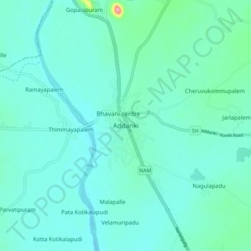
Name: Addanki topographic map, elevation, terrain.
Location: Addanki, Bapatla, Andhra Pradesh, 523201, India (15.77103 79.93379 15.85103 80.01379)
Average elevation: 38 m
Minimum elevation: 20 m
Maximum elevation: 153 m