
Greding topographic map
Interactive map
Click on the map to display elevation.
About this map
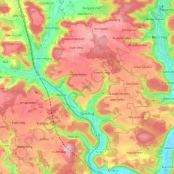
Name: Greding topographic map, elevation, terrain.
Location: Greding, Roth, Bavaria, 91171, Germany (48.99801 11.24889 49.13526 11.42661)
Average elevation: 488 m
Minimum elevation: 366 m
Maximum elevation: 592 m
Other topographic maps
Click on a map to view its topography, its elevation and its terrain.
Wendelstein
Wendelstein, Roth, Bavaria, 90530, Germany
Average elevation: 355 m