
Make a donation
Gear up for your next adventure:
As an Amazon Associate, this site earns from qualifying purchases at no extra cost to you.
Klamath Falls topographic map
Click on the map to display elevation.
Make a donation
Gear up for your next adventure:
As an Amazon Associate, this site earns from qualifying purchases at no extra cost to you.
Klamath Falls
According to the United States Census Bureau, the city has a total area of 20.66 square miles (53.51 km2), of which 19.81 square miles (51.31 km2) is land and 0.85 square miles (2.20 km2) is water. The elevation is 4,094 feet (1,248 m).
Make a donation
Gear up for your next adventure:
As an Amazon Associate, this site earns from qualifying purchases at no extra cost to you.
About this map
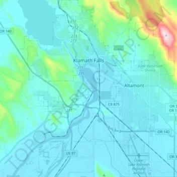
Name: Klamath Falls topographic map, elevation, terrain.
Average elevation: 1,312 m
Minimum elevation: 1,240 m
Maximum elevation: 1,888 m
Make a donation
Gear up for your next adventure:
As an Amazon Associate, this site earns from qualifying purchases at no extra cost to you.
Other topographic maps
Click on a map to view its topography, its elevation and its terrain.
Make a donation
Gear up for your next adventure:
As an Amazon Associate, this site earns from qualifying purchases at no extra cost to you.
Mount Scott
United States > Oregon > Klamath County
There is one trail to the summit of Mount Scott. Starting on Rim Drive, the trail is about 2.5 miles (4.0 km) long. It has many switchbacks, and ends at the fire lookout tower on the summit. The trailhead is at an elevation of 7,683 feet (2,342 m), and the trail climbs approximately 1,479 feet (451 m) to the…
Average elevation: 2,295 m
Lake of the Woods
United States > Oregon > Klamath County
Lake of the Woods is located near the crest of the Cascade Mountains in western Klamath County, Oregon. Its elevation is 4,949 feet (1,508 m) above sea level. The lake is surrounded by the Fremont–Winema National Forest. Lake of the Woods is 33 miles (53 km) west of Klamath Falls and 43 miles (69 km) east of…
Average elevation: 1,588 m
Make a donation
Gear up for your next adventure:
As an Amazon Associate, this site earns from qualifying purchases at no extra cost to you.