
Make a donation
Gear up for your next adventure:
As an Amazon Associate, this site earns from qualifying purchases at no extra cost to you.
Göreme topographic map
Click on the map to display elevation.
Make a donation
Gear up for your next adventure:
As an Amazon Associate, this site earns from qualifying purchases at no extra cost to you.
About this map
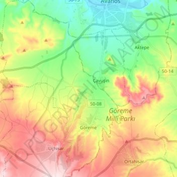
Name: Göreme topographic map, elevation, terrain.
Location: Göreme, Nevşehir, Central Anatolia Region, 50180, Turkey (38.61212 34.76149 38.71913 34.85785)
Average elevation: 1,118 m
Minimum elevation: 919 m
Maximum elevation: 1,386 m
Make a donation
Gear up for your next adventure:
As an Amazon Associate, this site earns from qualifying purchases at no extra cost to you.
Other topographic maps
Click on a map to view its topography, its elevation and its terrain.
Cappadocia
The area was featured in several films due to its topography. The 1983 Italian/French/Turkish film Yor, the Hunter from the Future was filmed in Cappadocia. The region was used for the 1989 science fiction film Slipstream to depict a cult of wind worshippers. In 2010 and early 2011, the film Ghost Rider:…
Average elevation: 1,167 m
Cappadocia
Cappadocia lies in central Anatolia, in the heartland of what is now Turkey. The relief consists of a high plateau over 1,000 m in altitude that is pierced by volcanic peaks, with Mount Erciyes (ancient Argaeus) near Kayseri (ancient Caesarea) being the tallest at 3,916 m. The boundaries of historical…
Average elevation: 1,167 m