
Woodford County topographic map
Interactive map
Click on the map to display elevation.
About this map
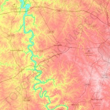
Name: Woodford County topographic map, elevation, terrain.
Location: Woodford County, Kentucky, United States (37.84710 -84.86568 38.19543 -84.62508)
Average elevation: 259 m
Minimum elevation: 146 m
Maximum elevation: 326 m
Other topographic maps
Click on a map to view its topography, its elevation and its terrain.
Midway
United States > Kentucky > Woodford County
Midway, Woodford County, Kentucky, United States
Average elevation: 256 m
Versailles
United States > Kentucky > Woodford County
Versailles, Woodford County, Kentucky, 40383, United States
Average elevation: 275 m