
Thank you for supporting this site ❤️
Make a donation
Make a donation
Gear up for your next adventure:
As an Amazon Associate, this site earns from qualifying purchases at no extra cost to you.
sn3 topographic map
Click on the map to display elevation.
Thank you for supporting this site ❤️
Make a donation
Make a donation
Gear up for your next adventure:
As an Amazon Associate, this site earns from qualifying purchases at no extra cost to you.
About this map
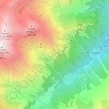
Name: sn3 topographic map, elevation, terrain.
Location: sn3, Rassa, Vercelli, Piedmont, Italy (45.75272 7.95618 45.77272 7.97618)
Average elevation: 1,833 m
Minimum elevation: 1,185 m
Maximum elevation: 2,640 m
Thank you for supporting this site ❤️
Make a donation
Make a donation
Gear up for your next adventure:
As an Amazon Associate, this site earns from qualifying purchases at no extra cost to you.