
Tallangatta topographic map
Interactive map
Click on the map to display elevation.
About this map
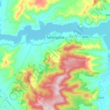
Name: Tallangatta topographic map, elevation, terrain.
Location: Tallangatta, Shire of Towong, Victoria, 3700, Australia (-36.26870 147.11462 -36.20204 147.25668)
Average elevation: 353 m
Minimum elevation: 179 m
Maximum elevation: 779 m
Other topographic maps
Click on a map to view its topography, its elevation and its terrain.
Lake Hume
Australia > Victoria > Tallangatta
Lake Hume, Tallangatta, Shire of Towong, Victoria, Australia
Average elevation: 288 m