
Make a donation
Gear up for your next adventure:
As an Amazon Associate, this site earns from qualifying purchases at no extra cost to you.
Boltigen topographic map
Click on the map to display elevation.
Make a donation
Gear up for your next adventure:
As an Amazon Associate, this site earns from qualifying purchases at no extra cost to you.
Boltigen
The municipality includes the cooperative farms (Bäuerten) of Boltigen, Adlemsried, Eschi, Oberbäuert (which includes Littisbach and Unterbächen), Reidenbach, Schwarzenmatt, Simmenegg and Weissenbach. The area includes the valley floor around the Simme River, both sides of the valley and the surrounding mountains up to an altitude of 2,235 m (7,333 ft).
Make a donation
Gear up for your next adventure:
As an Amazon Associate, this site earns from qualifying purchases at no extra cost to you.
About this map
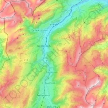
Name: Boltigen topographic map, elevation, terrain.
Average elevation: 1,459 m
Minimum elevation: 786 m
Maximum elevation: 2,261 m
Make a donation
Gear up for your next adventure:
As an Amazon Associate, this site earns from qualifying purchases at no extra cost to you.
Other topographic maps
Click on a map to view its topography, its elevation and its terrain.
Sankt Stephan
Switzerland > Bern > Obersimmental-Saanen administrative district > St. Stephan
Average elevation: 1,310 m
Gstaad
Switzerland > Bern > Obersimmental-Saanen administrative district
Long known for its walking and hiking trails of varying degrees of difficulty, the mountain air and ambiance attract guests year-round from around the world. Gstaad is also known for its ski and cross-country slopes and winter hiking trails. Glacier 3000 is a major attraction, offering guaranteed snow from…
Average elevation: 1,245 m
Make a donation
Gear up for your next adventure:
As an Amazon Associate, this site earns from qualifying purchases at no extra cost to you.
Leiterli
Switzerland > Bern > Obersimmental-Saanen administrative district > Lenk
Average elevation: 1,791 m
Jaunpass
Switzerland > Bern > Obersimmental-Saanen administrative district > Boltigen
Average elevation: 1,444 m
Sankt Stephan
Switzerland > Bern > Obersimmental-Saanen administrative district > St. Stephan > Sankt Stephan
Average elevation: 1,310 m
Make a donation
Gear up for your next adventure:
As an Amazon Associate, this site earns from qualifying purchases at no extra cost to you.
Saanen
Switzerland > Bern > Obersimmental-Saanen administrative district > Saanen > Saanen
Average elevation: 1,222 m
Stand
Switzerland > Bern > Obersimmental-Saanen administrative district > Saanen
Average elevation: 1,746 m