
Haunetal topographic map
Interactive map
Click on the map to display elevation.
About this map
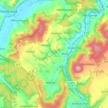
Name: Haunetal topographic map, elevation, terrain.
Location: Haunetal, Landkreis Hersfeld-Rotenburg, Hesse, 36166, Germany (50.71744 9.60431 50.81157 9.73972)
Average elevation: 313 m
Minimum elevation: 204 m
Maximum elevation: 509 m
Other topographic maps
Click on a map to view its topography, its elevation and its terrain.
Hohenroda
Germany > Hesse > Landkreis Hersfeld-Rotenburg
Hohenroda, Landkreis Hersfeld-Rotenburg, Hesse, 36284, Germany
Average elevation: 341 m
Heringen (Werra)
Germany > Hesse > Landkreis Hersfeld-Rotenburg
Heringen (Werra), Landkreis Hersfeld-Rotenburg, Hesse, 36266, Germany
Average elevation: 294 m
Bebra
Germany > Hesse > Landkreis Hersfeld-Rotenburg
Bebra, Landkreis Hersfeld-Rotenburg, Hesse, 36179, Germany
Average elevation: 312 m
Heenes
Germany > Hesse > Landkreis Hersfeld-Rotenburg
Heenes, Bad Hersfeld, Landkreis Hersfeld-Rotenburg, Hesse, Germany
Average elevation: 310 m
Bad Hersfeld
Germany > Hesse > Landkreis Hersfeld-Rotenburg
Bad Hersfeld, Landkreis Hersfeld-Rotenburg, Hesse, 36251, Germany
Average elevation: 281 m