
Villars-sur-Ollon topographic map
Interactive map
Click on the map to display elevation.
About this map
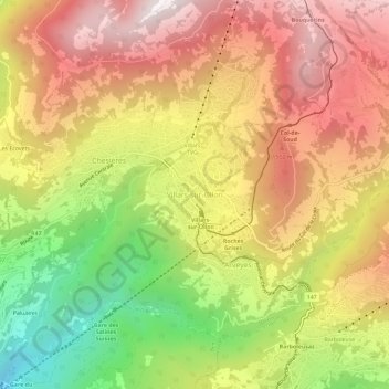
Name: Villars-sur-Ollon topographic map, elevation, terrain.
Location: Villars-sur-Ollon, Olun, District d'Aigle, Waadt, 1884, Schweiz (46.27776 7.03533 46.31776 7.07533)
Average elevation: 1,293 m
Minimum elevation: 588 m
Maximum elevation: 1,871 m
Other topographic maps
Click on a map to view its topography, its elevation and its terrain.
Rhonetal
Schweiz > Waadt > District d'Aigle
Rhonetal, District d'Aigle, Waadt, Schweiz
Average elevation: 1,378 m
Tour d'Aï
Schweiz > Waadt > District d'Aigle > Leysin
Tour d'Aï, Leysin, District d'Aigle, Waadt, 1854, Schweiz
Average elevation: 1,844 m
Les Diablerets
Schweiz > Waadt > District d'Aigle > Ormont-Dessus
Les Diablerets, Ormont-Dessus, District d'Aigle, Waadt, 1865, Schweiz
Average elevation: 1,453 m
Olun
Schweiz > Waadt > District d'Aigle
Olun, District d'Aigle, Waadt, Schweiz
Average elevation: 898 m