
Make a donation
Gear up for your next adventure:
As an Amazon Associate, this site earns from qualifying purchases at no extra cost to you.
Umjindi Local Municipality topographic map
Click on the map to display elevation.
Make a donation
Gear up for your next adventure:
As an Amazon Associate, this site earns from qualifying purchases at no extra cost to you.
About this map
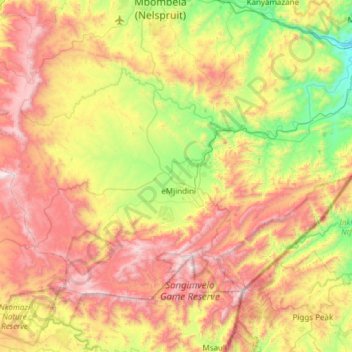
Name: Umjindi Local Municipality topographic map, elevation, terrain.
Average elevation: 1,007 m
Minimum elevation: 332 m
Maximum elevation: 1,889 m
Make a donation
Gear up for your next adventure:
As an Amazon Associate, this site earns from qualifying purchases at no extra cost to you.
Other topographic maps
Click on a map to view its topography, its elevation and its terrain.
Kanyamazane
South Africa > Mpumalanga > Ehlanzeni District Municipality > Mbombela
Average elevation: 637 m
Blyde River Canyon Nature Reserve
South Africa > Mpumalanga > Ehlanzeni District Municipality > Thaba Chweu Local Municipality
The Mogologolo (1,794 m), Mariepskop (1,944 m) and Hebronberg (1,767 m) massifs are partially included in the reserve. Elevation varies from 560 m to 1,944 m above sea level. Its resort areas are F.H. Odendaal and Swadeni, the latter only accessible from Limpopo province. The area of approximately 29,000…
Average elevation: 1,040 m
Forrest Falls
South Africa > Mpumalanga > Ehlanzeni District Municipality > Thaba Chweu Local Municipality
Average elevation: 1,311 m
Mananga
South Africa > Mpumalanga > Ehlanzeni District Municipality > Nkomazi
Average elevation: 541 m
Make a donation
Gear up for your next adventure:
As an Amazon Associate, this site earns from qualifying purchases at no extra cost to you.
Mashishing
South Africa > Mpumalanga > Ehlanzeni District Municipality > Thaba Chweu Local Municipality
Average elevation: 1,421 m
Graskop
South Africa > Mpumalanga > Ehlanzeni District Municipality > Thaba Chweu Local Municipality
Average elevation: 1,385 m
Marloth Park
South Africa > Mpumalanga > Ehlanzeni District Municipality > Nkomazi
Average elevation: 220 m
Kaapsehoop
South Africa > Mpumalanga > Ehlanzeni District Municipality > Mbombela
Average elevation: 1,505 m
Make a donation
Gear up for your next adventure:
As an Amazon Associate, this site earns from qualifying purchases at no extra cost to you.
Bosfontein
South Africa > Mpumalanga > Ehlanzeni District Municipality > Nkomazi > Bosfontein
Average elevation: 356 m
Talamati Bushveld Camp
South Africa > Mpumalanga > Ehlanzeni District Municipality > Bushbuckridge
Average elevation: 376 m
Girivana Waterhole
South Africa > Mpumalanga > Ehlanzeni District Municipality > Bushbuckridge
Average elevation: 324 m