
Tilly-la-Campagne topographic map
Interactive map
Click on the map to display elevation.
About this map
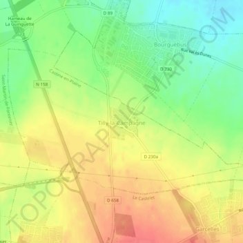
Name: Tilly-la-Campagne topographic map, elevation, terrain.
Average elevation: 67 m
Minimum elevation: 37 m
Maximum elevation: 94 m
Other topographic maps
Click on a map to view its topography, its elevation and its terrain.
Rocquancourt
France > Normandie > Calvados > Castine-en-Plaine
Rocquancourt, Castine-en-Plaine, Caen, Calvados, Normandie, France métropolitaine, 14540, France
Average elevation: 77 m
Hubert-Folie
France > Normandie > Calvados > Castine-en-Plaine
Hubert-Folie, Castine-en-Plaine, Caen, Calvados, Normandie, France métropolitaine, 14540, France
Average elevation: 50 m