
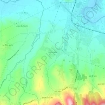
Les Auriols topographic map
Interactive map
Click on the map to display elevation.
About this map
Name: Les Auriols topographic map, elevation, terrain.
Average elevation: 230 m
Minimum elevation: 177 m
Maximum elevation: 379 m
Other topographic maps
Click on a map to view its topography, its elevation and its terrain.
Les Bousquets
France > Occitanie > Tarn > Labruguière
Les Bousquets, Labruguière, Castres, Tarn, Occitanie, France métropolitaine, 81290, France
Average elevation: 324 m
Les Gaux
France > Occitanie > Tarn > Labruguière
Les Gaux, Labruguière, Castres, Tarn, Occitanie, France métropolitaine, 81290, France
Average elevation: 310 m