
羊八井镇 topographic map
Interactive map
Click on the map to display elevation.
About this map
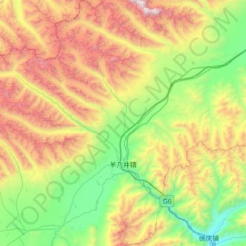
Name: 羊八井镇 topographic map, elevation, terrain.
Location: 羊八井镇, 当雄县, 拉萨市, 西藏自治区, 中国 (29.95228 90.22110 30.38747 90.71587)
Average elevation: 5,083 m
Minimum elevation: 3,968 m
Maximum elevation: 7,107 m
羊八井镇(藏語:ཡངས་པ་ཅན,威利转写:yangs pa can;意为“宽阔”)是中国西藏自治区拉萨市当雄县下辖的一个镇,位于拉萨西北90多千米的藏北草原上,海拔4300多米,面积800平方公里。当地含有丰富的地热资源,温泉数量最多,水温是中国温泉中最高的,高达93℃~172℃,每秒自然热流量11万千卡。1976年建成中国第一座地热发电站——羊八井地热电厂。
Other topographic maps
Click on a map to view its topography, its elevation and its terrain.