
Ntoto topographic map
Interactive map
Click on the map to display elevation.
About this map
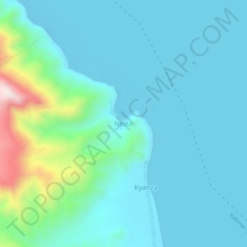
Name: Ntoto topographic map, elevation, terrain.
Location: Ntoto, Tanganyika, Democratische Republiek Congo (-6.98836 29.71036 -6.94836 29.75036)
Average elevation: 854 m
Minimum elevation: 758 m
Maximum elevation: 1,342 m
Other topographic maps
Click on a map to view its topography, its elevation and its terrain.
Kalemie
Democratische Republiek Congo > Tanganyika > Kalemie
Kalemie, Tanganyika, Democratische Republiek Congo
Average elevation: 813 m