Geolocate

Ashigarashimo County topographic map

Interactive map

Click on the map to display elevation.

About this map

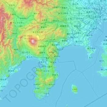
Name: Ashigarashimo County topographic map, elevation, terrain.

Location: Ashigarashimo County, Kanagawa Prefecture, Japan (34.50225 138.36241 35.90225 139.76241)

Average elevation: 322 m

Minimum elevation: -3 m

Maximum elevation: 3,700 m

Other topographic maps

Click on a map to view its topography, its elevation and its terrain.

Tokyo

Japan

The mainland portion of Tokyo lies northwest of Tokyo Bay and measures about 90 km (56 mi) east to west and 25 km (16 mi) north to south. The average elevation in Tokyo is 40 m (131 ft). Chiba Prefecture borders it to the east, Yamanashi to the west, Kanagawa to the south, and Saitama to the north. Mainland…

Average elevation: 22 m

Ofunato

Japan

Average elevation: 151 m

Kagoshima Prefecture

Japan

Average elevation: 11 m

Osaka

Japan

Average elevation: 10 m

Okinawa

Japan

Average elevation: 36 m

Tokyo

Japan

The mainland portion of Tokyo lies northwest of Tokyo Bay and measures about 90 km (56 mi) east to west and 25 km (16 mi) north to south. The average elevation in Tokyo is 40 m (131 ft). Chiba Prefecture borders it to the east, Yamanashi to the west, Kanagawa to the south, and Saitama to the north. Mainland…

Average elevation: 22 m

Kyoto

Japan

Average elevation: 311 m

Yokohama

Japan

Yokohama has a total area of 437.38 km2 (168.87 sq mi) at an elevation of 5 metres (16 ft) above sea level. It is the capital of Kanagawa Prefecture, bordered to the east by Tokyo Bay and located in the middle of the Kantō plain. The city is surrounded by hills and the characteristic mountain system of the…

Average elevation: 23 m

Nagoya

Japan

Average elevation: 17 m

Fukuoka

Japan

Average elevation: 71 m

Kyūshū

Japan

The total area is 36,782.37 km2 (14,201.75 sq mi) which makes it the 37th largest island in the world. It's slightly larger than Taiwan island 35,808 km2 (13,826 sq mi). The highest elevation is 1791 meters (5876 feet) on Mount Kujū.

Average elevation: 116 m

Koshigaya

Japan

Koshigaya is situated in eastern Saitama Prefecture, in the alluvial plain of the Nakagawa basin between the Omiya plateau and the Shimosa plateau. Most of the city area is flat with an average elevation of only five meters above sea level. Many rivers, including the Motoara River, Naka River, Ayase River,…

Average elevation: 7 m

Hiroshima

Japan

Average elevation: 300 m

Naoshima

Japan > Kagawa County

Average elevation: 8 m

Kyoto

Japan

Average elevation: 307 m

Asahikawa

Japan

Average elevation: 275 m

Chiba Prefecture

Japan

Average elevation: 15 m

Iwade

Japan

Average elevation: 126 m

Bunkyō

Japan

Average elevation: 22 m

Iwata

Japan

Average elevation: 39 m

Azabudai

Japan > Minato

Average elevation: 23 m

Fujiyoshida

Japan

Fujiyoshida lies at the northern base of Mount Fuji, and is built upon old lava flows. It is considered a high-elevation city in Japan, at 650 to 850 metres (2,140 to 2,800 feet) above sea level. The city is also located between two of the Fuji Five Lakes. The Katsura River flows through the eastern part of…

Average elevation: 1,161 m

Sammu

Japan

Average elevation: 19 m

Honshu

Japan

Average elevation: 91 m

Sendai

Japan

Sendai is located at lat. 38°16'05" north, long. 140°52'11" east. The city's area is 788.09 km2 (304.28 sq mi), and stretches from the Pacific Ocean to the Ōu Mountains, which are the east and west borders of Miyagi Prefecture. As a result, the city's geography is quite diverse. Eastern Sendai is a plains…

Average elevation: 185 m

Shikoku

Japan

Average elevation: 156 m

Shinjuku

Japan

Naturally, most of Shinjuku is occupied by the Yodobashi Plateau, the most elevated portion of which extends through most of the Shinjuku Station area. The Kanda River runs through the Ochiai and Totsuka areas near sea level, but the Toshima Plateau also builds elevation in the northern extremities of Totsuka…

Average elevation: 35 m

Fujisawa

Japan

Fujisawa has three major topographical features: the island of Enoshima to the south connected to the Katase shoreline area by a road bridge, and two rivers, the Hikiji and the Sakai, which run north-south. The Hikiji can be traced from an area designated as a nature reserve park in the city of Yamato and…

Average elevation: 19 m

Gifu Castle

Japan > Gifu

Average elevation: 66 m

Osaka

Japan

Average elevation: 10 m

Kannami

Japan > Tagata County

Average elevation: 221 m

Ibigawa

Japan > Ibi County

Average elevation: 494 m

Kosai

Japan

Average elevation: 8 m

Sanagochi

Japan > Myodo County

Average elevation: 351 m

Arisugawa River

Japan > Kyoto

Average elevation: 99 m

Prince Arisugawa Memorial Park

Japan > Minato

Average elevation: 27 m

Fuchu

Japan

Fuchū is located about 20 km west of the centre of Tokyo. Using the Keiō Line from Shinjuku, it is 25 minutes to Fuchū Station (main station). It spreads across the Musashino Terrace on the left bank of the Tama River, facing the Tama hills on the opposite shore. The Tama River flows through the…

Average elevation: 65 m

Osaka

Japan

Average elevation: 10 m

Gifu Castle

Japan > Gifu

Average elevation: 66 m

Kiba Park

Japan > Koto

Average elevation: 7 m

Koganei

Japan

Koganei is approximately at the center of Tokyo metropolis, and is located about 20 kilometers west of Shinjuku, where Tokyo Metropolitan Government has its headquarters. It is flanked on the north and the south by two large parks. To the north is Koganei Park, which includes the Edo-Tokyo Open Air…

Average elevation: 66 m

Myoko

Japan

Average elevation: 640 m

七号通り公園

Japan > Shibuya

Average elevation: 40 m

Kumamoto Prefecture

Japan

Average elevation: 259 m

Tajimi

Japan

Average elevation: 215 m

Suginami

Japan

Average elevation: 46 m

Kodaira

Japan

Average elevation: 77 m

Watari County

Japan

Average elevation: 70 m

Miyoshi

Japan

Average elevation: 615 m

Kora

Japan > Inukami County

Average elevation: 131 m

Nagawa

Japan > Chiisagata County

Average elevation: 1,164 m

Chubu Region

Japan

Average elevation: 251 m

Hakodate

Japan

Average elevation: 139 m

Beppu

Japan

Around the city are mountains or highlands with elevations of several hundreds meters above sea level. Most of those mountains are Quaternary volcanoes. Particularly, locations such as Mount Tsurumi is relatively new, and fumarolic activities are observed. Besides Mount Tsurumi, Mount Yufu, Mount Ohira and…

Average elevation: 266 m

Kobe

Japan

Mount Rokkō overlooks Kobe at an elevation of 931 m (3,054 ft). During the autumn season, it is famous for the rich change in colors of its forests.

Average elevation: 115 m

Fujimi

Japan

Located in southwestern Saitama Prefecture, Fujimi is in the middle of the Kantō plain with an average altitude of 8 to 21 meters above sea level. It is approximately 10 kilometers from the prefectural capital at Saitama and 30 kilometers from downtown Tokyo.The northeastern half of the city area is a lowland…

Average elevation: 16 m

Aina

Japan > Atsugi > Aina

Average elevation: 61 m

Hirosaki

Japan

Average elevation: 226 m

Hakone

Japan > Ashigarashimo County

Hakone is characterized by its rugged topography, featuring a mix of mountainous terrain, valleys, and volcanic landscapes. Nestled within the greater Fuji-Hakone-Izu National Park, Hakone's elevation varies dramatically, with peaks rising over 4,000 feet and low-lying areas near Lake Ashi, which sits at…

Average elevation: 722 m

Minami-Alps

Japan

Average elevation: 777 m

Koganei

Japan

Koganei is approximately at the center of Tokyo metropolis, and is located about 20 kilometers west of Shinjuku, where Tokyo Metropolitan Government has its headquarters. It is flanked on the north and the south by two large parks. To the north is Koganei Park, which includes the Edo-Tokyo Open Air…

Average elevation: 66 m

Imabari

Japan

Imabari is located in central Ehime Prefecture, facing the Seto Inland Sea to the east and northwest, and including a portion of the Geiyo Islands in between Shikoku and Honshu, including Ōmishima, Ōshima and Hakatajima. The land portion occupies the northeastern part of the Takanawa Peninsula. The highest…

Average elevation: 76 m

Atsugi

Japan

Average elevation: 67 m

Hiroshima

Japan

Average elevation: 300 m

Gero

Japan

Average elevation: 933 m

Tochigi Prefecture

Japan

Average elevation: 496 m

Chiyoda

Japan

Average elevation: 23 m

Murata

Japan > Shibata County

Average elevation: 130 m

Ibaraki Prefecture

Japan

The northern third of the prefecture is mountainous and in the center is the Tsukuba Mountains (筑波 山地). Its main mountains are: mount Yamizo with an elevation of 1022 m on the border with Fukushima and Tochigi prefectures (tripoint), mount Takasasa with 922 m, mount Tsukuba with two peaks Nyotai-San at…

Average elevation: 82 m

Takatsuki

Japan

Takatsuki is located in the northeastern part of Osaka Prefecture. The city is approximately 10.4 kilometers east-to-west and 22.7 kilometers north-to-south. The north is bounded by the Hokusetsu mountain range and the south by the Yodo River, and the topography is high in the north and low in the south. The…

Average elevation: 154 m

Hakone

Japan > Ashigarashimo County

Average elevation: 364 m

Gunma Prefecture

Japan

Average elevation: 768 m

Toyota

Japan

Average elevation: 202 m

Aomori Prefecture

Japan

Average elevation: 120 m

Kanda

Japan > Miyako County

Average elevation: 57 m

Inagi

Japan

Average elevation: 70 m

Fukushima Prefecture

Japan

Fukushima city is located in the Fukushima Basin's southwest area and nearby mountains. Located on the central eastern seaboard a part of the Pacifim rim. A region with high tectonic activity given its location where the Pacific and Eurasian continental plates collide - a part the Ring of Fire. " Aizuwakamatsu…

Average elevation: 402 m

Takaoka

Japan

Average elevation: 41 m

Shimamoto

Japan > Mishima County

Shimamoto occupies a large part of the Minase River basin, a tributary of the Yodo River in far northeastern Osaka Prefecture. The town area stretches from northwest to southeast, and the elevation increases towards the northwest. Nearly 70% of the town is mountainous and hilly. The urban area is located in a…

Average elevation: 165 m

Toyohashi

Japan

Average elevation: 17 m

Saitama Prefecture

Japan

The topography of Saitama Prefecture is largely divided by the Hachiōji Tectonic Line, which runs through Kodama, Ogawa, and Hannō, into the western mountain area and the eastern lowland area. The altitude, highest on the western side, gradually lowers eastward from mountain ranges to hills to plateaus to…

Average elevation: 230 m

Matsumoto

Japan

Average elevation: 1,117 m

Omuta

Japan

Average elevation: 43 m

Suita

Japan

Suita is located in northern Osaka Prefecture. The northern part of the city is occupied by the gently sloping Senri Hills, and the southern part is a plain made up of the Yodo River, Aui River, Kanzaki River, and sediments carried from rivers that originate in Senri Hills. The elevation of the city ranges…

Average elevation: 33 m

Miyakonojo

Japan

Average elevation: 316 m

Oyama

Japan

Average elevation: 37 m

Fujisawa

Japan

Fujisawa has three major topographical features: the island of Enoshima to the south connected to the Katase shoreline area by a road bridge, and two rivers, the Hikiji and the Sakai, which run north-south. The Hikiji can be traced from an area designated as a nature reserve park in the city of Yamato and…

Average elevation: 19 m

Uchiko

Japan > Kita County

Average elevation: 308 m

Saitama Prefecture

Japan

The topography of Saitama Prefecture is largely divided by the Hachiōji Tectonic Line, which runs through Kodama, Ogawa, and Hannō, into the western mountain area and the eastern lowland area. The altitude, highest on the western side, gradually lowers eastward from mountain ranges to hills to plateaus to…

Average elevation: 230 m

Kagoshima Prefecture

Japan

Average elevation: 11 m

Tokoname

Japan

Average elevation: 9 m

Gunma Prefecture

Japan

Average elevation: 768 m

Kizugawa

Japan

Average elevation: 120 m

Kobe

Japan

Mount Rokkō overlooks Kobe at an elevation of 931 m (3,054 ft). During autumn, it is famous for the rich change in colors of its forests.

Average elevation: 115 m

Kōfu

Japan

Average elevation: 865 m

Lake Yamanaka

Japan > Minamitsuru County > Yamanakako

Lake Yamanaka is the largest of the Fuji Five Lakes in surface area and the highest in elevation. It is the third highest lake in Japan, with a mean surface altitude of 980.5 metres (3,217 ft). It is also the shallowest of the Fuji Five Lakes, with a maximum water depth of 13.5 metres (44 ft). It was formed by…

Average elevation: 1,030 m

Kanda

Japan > Miyako County

Average elevation: 57 m

Shinkō

Japan > Yokohama

Average elevation: 5 m

Higashiyama Ward

Japan > Kyoto

Average elevation: 75 m