
Suresnes topographic map
Interactive map
Click on the map to display elevation.
About this map
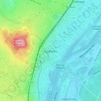
Name: Suresnes topographic map, elevation, terrain.
Average elevation: 62 m
Minimum elevation: 26 m
Maximum elevation: 166 m
La superficie de la commune est de 379 hectares ; l'altitude varie de 29 à 162 mètres[1]. Le niveau le plus bas est la Seine, le plus élevé est le mont Valérien.
Other topographic maps
Click on a map to view its topography, its elevation and its terrain.
Les Chailliers
France > Île-de-France > Hauts-de-Seine > Nanterre
Les Chailliers, Quartier du Plateau - Mont-Valérien, Nanterre, Hauts-de-Seine, Île-de-France, France métropolitaine, 92000, France
Average elevation: 78 m
Chaville
France > Île-de-France > Hauts-de-Seine
Chaville, Boulogne-Billancourt, Hauts-de-Seine, Île-de-France, France métropolitaine, 92370, France
Average elevation: 127 m
Neuilly-sur-Seine
France > Île-de-France > Hauts-de-Seine
Neuilly-sur-Seine, Nanterre, Hauts-de-Seine, Île-de-France, France métropolitaine, 92200, France
Average elevation: 41 m
Boulogne-Billancourt
France > Île-de-France > Hauts-de-Seine > Boulogne-Billancourt
Boulogne-Billancourt, Hauts-de-Seine, Île-de-France, France métropolitaine, 92100, France
Average elevation: 43 m
Issy-les-Moulineaux
France > Île-de-France > Hauts-de-Seine
Issy-les-Moulineaux, Boulogne-Billancourt, Hauts-de-Seine, Île-de-France, France métropolitaine, 92130, France
Average elevation: 60 m