Geolocate

Moeling topographic map

Interactive map

Click on the map to display elevation.

About this map

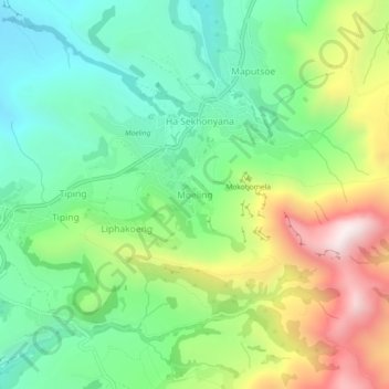
Name: Moeling topographic map, elevation, terrain.

Location: Moeling, Quthing District, Lesotho (-30.30049 27.85476 -30.26049 27.89476)

Average elevation: 1,786 m

Minimum elevation: 1,477 m

Maximum elevation: 2,350 m

Other topographic maps

Click on a map to view its topography, its elevation and its terrain.

Ha Maliau

Lesotho > Quthing District

Ha Maliau, Quthing District, Lesotho

Average elevation: 1,810 m

Moyeni (Quthing)

Lesotho > Quthing District > Moyeni (Quthing)

Moyeni (Quthing), Quthing District, Lesotho

Average elevation: 1,644 m