
Valle de Santiago topographic map
Interactive map
Click on the map to display elevation.
About this map
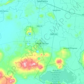
Name: Valle de Santiago topographic map, elevation, terrain.
Location: Valle de Santiago, Guanajuato, México (20.24642 -101.46013 20.54716 -101.07853)
Average elevation: 1,782 m
Minimum elevation: 1,680 m
Maximum elevation: 2,441 m
Other topographic maps
Click on a map to view its topography, its elevation and its terrain.
Parque Las Américas
México > Guanajuato > Pénjamo
Parque Las Américas, Las Americas, Pénjamo, Guanajuato, 36904, México
Average elevation: 1,757 m