
English Bicknor topographic map
Interactive map
Click on the map to display elevation.
About this map
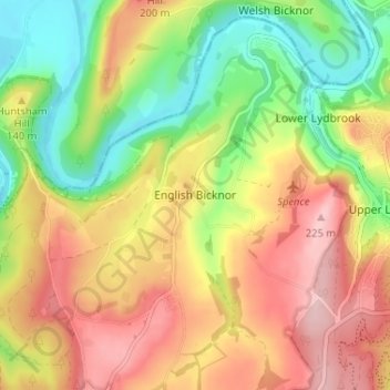
Name: English Bicknor topographic map, elevation, terrain.
Average elevation: 122 m
Minimum elevation: 17 m
Maximum elevation: 228 m
Gloucestershire trails, hiking, mountain biking, running and outdoor activities
Other topographic maps
Click on a map to view its topography, its elevation and its terrain.
Newland
United Kingdom > England > Gloucestershire > Forest of Dean > Newland
Average elevation: 151 m
Speech House Lake
United Kingdom > England > Gloucestershire > Forest of Dean
Average elevation: 148 m
Lydney Harbour
United Kingdom > England > Gloucestershire > Forest of Dean > Lydney > Naas
Average elevation: 7 m
Coleford
United Kingdom > England > Gloucestershire > Forest of Dean > Coleford
Average elevation: 193 m
Land Grove
United Kingdom > England > Gloucestershire > Forest of Dean > Mitcheldean
Average elevation: 157 m