
Ratnagiri topographic map
Interactive map
Click on the map to display elevation.
About this map
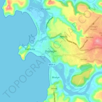
Name: Ratnagiri topographic map, elevation, terrain.
Location: Ratnagiri, Maharashtra, 415612, India (16.95335 73.25544 17.03335 73.33544)
Average elevation: 30 m
Minimum elevation: -3 m
Maximum elevation: 136 m
Ratnagiri is located at 16°59′N 73°18′E / 16.98°N 73.3°E / 16.98; 73.3. It has an average elevation of 11 meters (36 feet). The Sahyadri mountains border Ratnagiri to the east
Other topographic maps
Click on a map to view its topography, its elevation and its terrain.
Gomukh
India > Maharashtra > Ratnagiri > Jaigarh
Gomukh, Jaigarh, Ratnagiri, Maharashtra, India
Average elevation: 7 m