
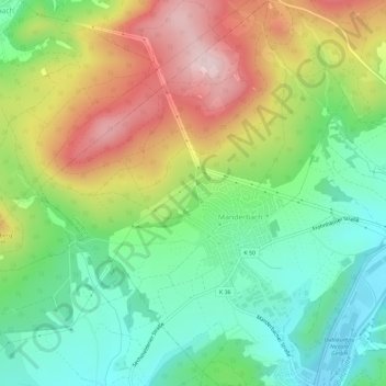
Manderbach topographic map
Interactive map
Click on the map to display elevation.
About this map
Name: Manderbach topographic map, elevation, terrain.
Average elevation: 372 m
Minimum elevation: 244 m
Maximum elevation: 562 m
Other topographic maps
Click on a map to view its topography, its elevation and its terrain.
Frohnhausen
Deutschland > Hessen > Lahn-Dill-Kreis > Dillenburg
Frohnhausen, Dillenburg, Lahn-Dill-Kreis, Hessen, 35684, Deutschland
Average elevation: 381 m
Nanzenbach
Deutschland > Hessen > Lahn-Dill-Kreis > Dillenburg
Nanzenbach, Dillenburg, Lahn-Dill-Kreis, Hessen, 35690, Deutschland
Average elevation: 409 m
Niederscheld
Deutschland > Hessen > Lahn-Dill-Kreis > Dillenburg
Niederscheld, Dillenburg, Lahn-Dill-Kreis, Hessen, 35687, Deutschland
Average elevation: 295 m
Eibach
Deutschland > Hessen > Lahn-Dill-Kreis > Dillenburg
Eibach, Dillenburg, Lahn-Dill-Kreis, Hessen, 35689, Deutschland
Average elevation: 360 m
Hunsbach
Deutschland > Hessen > Lahn-Dill-Kreis > Dillenburg > Frohnhausen
Hunsbach, Frohnhausen, Dillenburg, Lahn-Dill-Kreis, Hessen, 35684, Deutschland
Average elevation: 381 m