
Ashland topographic map
Interactive map
Click on the map to display elevation.
About this map
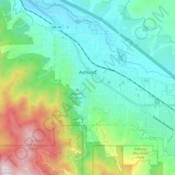
Name: Ashland topographic map, elevation, terrain.
Location: Ashland, Jackson County, Oregon, États-Unis d'Amérique (42.16720 -122.73599 42.21605 -122.65110)
Average elevation: 774 m
Minimum elevation: 503 m
Maximum elevation: 1,477 m
Other topographic maps
Click on a map to view its topography, its elevation and its terrain.
Medford
États-Unis d'Amérique > Oregon > Jackson County
Medford, Jackson County, Oregon, États-Unis d'Amérique
Average elevation: 441 m
Beagle
États-Unis d'Amérique > Oregon > Jackson County
Beagle, Jackson County, Oregon, États-Unis d'Amérique
Average elevation: 467 m