
Make a donation
Gear up for your next adventure:
As an Amazon Associate, this site earns from qualifying purchases at no extra cost to you.
Negoiu topographic map
Click on the map to display elevation.
Make a donation
Gear up for your next adventure:
As an Amazon Associate, this site earns from qualifying purchases at no extra cost to you.
Negoiu
Negoiu Peak (Romanian: Vârful Negoiu pronounced [neˈɡoju]; Hungarian: Negoj-csúcs) is a mountain peak in the Făgăraș Mountains of the Southern Carpathians, located in Sibiu County, Romania, with an elevation of 2,535 m (8,317 ft). It is the second highest peak in Romania after the 2,544 m (8,346 ft) Moldoveanu Peak.
Make a donation
Gear up for your next adventure:
As an Amazon Associate, this site earns from qualifying purchases at no extra cost to you.
About this map
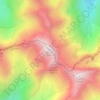
Name: Negoiu topographic map, elevation, terrain.
Location: Negoiu, Sălătrucu, Argeș, Romania (45.58500 24.55852 45.58510 24.55862)
Average elevation: 2,059 m
Minimum elevation: 1,459 m
Maximum elevation: 2,506 m
Make a donation
Gear up for your next adventure:
As an Amazon Associate, this site earns from qualifying purchases at no extra cost to you.