
Make a donation
Gear up for your next adventure:
As an Amazon Associate, this site earns from qualifying purchases at no extra cost to you.
A Laracha topographic map
Click on the map to display elevation.
Make a donation
Gear up for your next adventure:
As an Amazon Associate, this site earns from qualifying purchases at no extra cost to you.
About this map
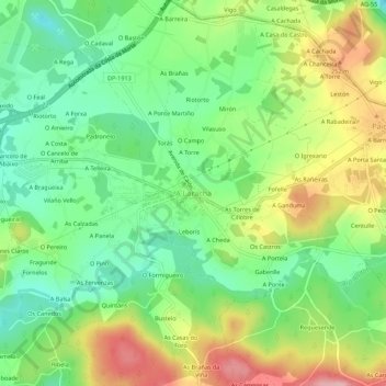
Name: A Laracha topographic map, elevation, terrain.
Location: A Laracha, Bergantiños, A Coruña, Galicia, 15145, Spain (43.22847 -8.60162 43.26847 -8.56162)
Average elevation: 186 m
Minimum elevation: 114 m
Maximum elevation: 294 m
Make a donation
Gear up for your next adventure:
As an Amazon Associate, this site earns from qualifying purchases at no extra cost to you.
Other topographic maps
Click on a map to view its topography, its elevation and its terrain.
Make a donation
Gear up for your next adventure:
As an Amazon Associate, this site earns from qualifying purchases at no extra cost to you.
Praia de Baldaio - As Saíñas
Spain > Galicia > Bergantiños > Carballo > A Pedra do Sal
Average elevation: 13 m