
Orlovice topographic map
Interactive map
Click on the map to display elevation.
About this map
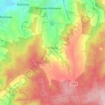
Name: Orlovice topographic map, elevation, terrain.
Location: Orlovice, okres Vyškov, South Moravian Region, Czechia (49.21649 17.05275 49.25768 17.12481)
Average elevation: 365 m
Minimum elevation: 238 m
Maximum elevation: 469 m
Other topographic maps
Click on a map to view its topography, its elevation and its terrain.
Rychtářov
Czechia > South Moravian Region > Vyškov
Rychtářov (German: Richtersdorf) is a former village, today a part of the town of Vyškov in the South Moravian Region of the Czech Republic. Located approximately 10 kilometres (6 mi) north of Vyškov and 27 kilometres (17 mi) north-east of Brno, it lies at an altitude of 401 m above sea level. Rychtářov…
Average elevation: 402 m