
Luwingu District topographic map
Interactive map
Click on the map to display elevation.
About this map
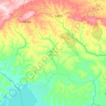
Name: Luwingu District topographic map, elevation, terrain.
Location: Luwingu District, Northern Province, Zambia (-11.03178 29.81635 -10.07078 30.78565)
Average elevation: 1,262 m
Minimum elevation: 1,160 m
Maximum elevation: 1,560 m
Other topographic maps
Click on a map to view its topography, its elevation and its terrain.
Mbala
Zambia > Northern Province > Mbala
The town is at the edge of the plateau covering most of Zambia, at an elevation of 1670 m, about 900 m higher than Lake Tanganyika, which comes within 22 km (straight-line distance). The escarpment above the lake is the end of the Albertine Rift, the western branch of the East Africa Rift, and the Mbala area…
Average elevation: 1,632 m