
Labach topographic map
Interactive map
Click on the map to display elevation.
About this map
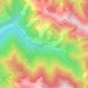
Name: Labach topographic map, elevation, terrain.
Average elevation: 1,324 m
Minimum elevation: 685 m
Maximum elevation: 1,919 m
Other topographic maps
Click on a map to view its topography, its elevation and its terrain.
Anc. mines
France > Occitanie > Haute-Garonne > Melles
Anc. mines, Melles, Saint-Gaudens, Haute-Garonne, Occitanie, France métropolitaine, 31440, France
Average elevation: 1,582 m