
New Haven topographic map
Interactive map
Click on the map to display elevation.
About this map
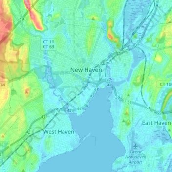
Name: New Haven topographic map, elevation, terrain.
Location: New Haven, New Haven County, Connecticut, United States (41.24643 -72.99805 41.35039 -72.86042)
Average elevation: 22 m
Minimum elevation: -3 m
Maximum elevation: 138 m
Other topographic maps
Click on a map to view its topography, its elevation and its terrain.
Branford Court
United States > Connecticut > New Haven County > New Haven
Branford Court, Downtown, New Haven, New Haven County, Connecticut, United States
Average elevation: 13 m