
Frithy and Chadacre Woods topographic map
Interactive map
Click on the map to display elevation.
About this map
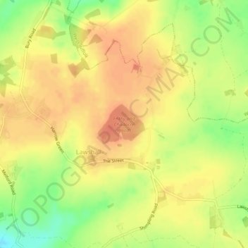
Name: Frithy and Chadacre Woods topographic map, elevation, terrain.
Average elevation: 97 m
Minimum elevation: 69 m
Maximum elevation: 112 m
England trails, hiking, mountain biking, running and outdoor activities
Other topographic maps
Click on a map to view its topography, its elevation and its terrain.
Bury St Edmunds
United Kingdom > England > West Suffolk > Bury St Edmunds
The name Bury is etymologically connected with borough, which has cognates in other Germanic languages such as the German burg meaning "fortress, castle"; Old Norse borg meaning "wall, castle"; and Gothic baurgs meaning "city". They all derive from Proto-Germanic *burgs meaning "fortress". This in turn derives…
Average elevation: 59 m