
Make a donation
Gear up for your next adventure:
As an Amazon Associate, this site earns from qualifying purchases at no extra cost to you.
Saradna topographic map
Click on the map to display elevation.
Make a donation
Gear up for your next adventure:
As an Amazon Associate, this site earns from qualifying purchases at no extra cost to you.
About this map
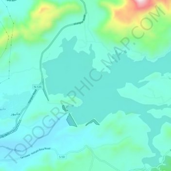
Name: Saradna topographic map, elevation, terrain.
Location: Saradna, Khyber Pakhtunkhwa, Pakistan, Khanpur Dam (33.78869 72.92090 33.83130 72.97485)
Average elevation: 630 m
Minimum elevation: 538 m
Maximum elevation: 1,053 m
Make a donation
Gear up for your next adventure:
As an Amazon Associate, this site earns from qualifying purchases at no extra cost to you.
Other topographic maps
Click on a map to view its topography, its elevation and its terrain.
Khyber Pakhtunkhwa
Most precipitation falls as thunderstorms or snow during winter and spring, so that the climate at the lowest elevations is classed as Mediterranean (Csa), continental Mediterranean (Dsa) or semi-arid (BSk). Summers are extremely dry in the north of Chitral district and receive only a little rain in the south…
Average elevation: 2,135 m
Buner District
Buner's elevation starts at 1200 ft in the South in Totalai and reaches a maximum height of 9,550 ft at the Dosara Peak in the North. The majority of the hills that encircle the Buner District are covered in pine trees. Barandu, Chamla, and Budal are the three principal rivers; the former flows through the…
Average elevation: 953 m
Bumbagh
Pakistan > Khyber Pakhtunkhwa > Chitrāl District > Torkhow-Molkhow Tehsil
Average elevation: 2,056 m
Make a donation
Gear up for your next adventure:
As an Amazon Associate, this site earns from qualifying purchases at no extra cost to you.
Abbottabad
Pakistan > Khyber Pakhtunkhwa > Abbottābād District
Abbottabad (/ˈæbətəbɑːd/; Urdu, Hindko: ایبٹ آباد, romanized: aibṭabād, pronounced [ɛːbʈəˈbaːd̪]) is the capital city of Abbottabad District in the Hazara region of eastern Khyber Pakhtunkhwa, Pakistan. It is the 40th largest city in Pakistan and fourth largest in the province of Khyber…
Average elevation: 1,363 m
Lakki Marwat District
The district is a combination of hills and sandy plains. The hilly areas are along the boundaries of the district especially in the east, southeast, southwest and northwest. In the southeast, the Marwat range separates Lakki Marwat from Dera Ismail Khan District while in the east the Karak Niazi range…
Average elevation: 353 m
Make a donation
Gear up for your next adventure:
As an Amazon Associate, this site earns from qualifying purchases at no extra cost to you.
Bajaur District
Bajaur is about 45 miles (72 km) long and 20 miles (32 km) wide. It lies at a high elevation to the east of the Kunar Valley of Afghanistan from which it is separated by a continuous line of rugged frontier hills. The old road from Afghanistan's Kabul to Pakistan went through Bajaur before a new pass, Khyber…
Average elevation: 1,172 m
Make a donation
Gear up for your next adventure:
As an Amazon Associate, this site earns from qualifying purchases at no extra cost to you.
Drosh Tehsil
Pakistan > Khyber Pakhtunkhwa > Chitrāl District
Khowar is by the majority of the people in Drosh with a few speakers of Pashto. Drosh is low elevation and is a large village in Chitral District on the traditional trade route to Drosh-Jalalabad Road.
Average elevation: 3,012 m
Make a donation
Gear up for your next adventure:
As an Amazon Associate, this site earns from qualifying purchases at no extra cost to you.
Hindu Kush
Pakistan > Khyber Pakhtunkhwa > Chitrāl District > Chitral Tehsil
Average elevation: 5,281 m
Make a donation
Gear up for your next adventure:
As an Amazon Associate, this site earns from qualifying purchases at no extra cost to you.
Make a donation
Gear up for your next adventure:
As an Amazon Associate, this site earns from qualifying purchases at no extra cost to you.
Dera Ismail Khan
Pakistan > Khyber Pakhtunkhwa > Dera Ismail Khan District
D. I Khan is situated at an altitude of 177 metres above sea level.
Average elevation: 177 m
Make a donation
Gear up for your next adventure:
As an Amazon Associate, this site earns from qualifying purchases at no extra cost to you.
Bumburait
Pakistan > Khyber Pakhtunkhwa > Chitrāl District > Chitral Tehsil
Average elevation: 2,446 m
Charsadda
Pakistan > Khyber Pakhtunkhwa > Charsadda District
Chārsadda (Pashto: چارسده; pronounce; Urdu: چارسدہ; pronounce) is a town and headquarters of Charsadda District, in the Khyber Pakhtunkhwa province of Pakistan. It is the 85th-largest city of Pakistan, according to 2017 census. Located in the Valley of Peshawar, Charsadda lies about 29 kilometres…
Average elevation: 317 m
Make a donation
Gear up for your next adventure:
As an Amazon Associate, this site earns from qualifying purchases at no extra cost to you.
Mardan
Pakistan > Khyber Pakhtunkhwa > Mardān District
Mardan is located in the south west of the district at 34°12'0N 72°1'60E and an altitude of 283 metres (928 ft). Mardan is a district headquarter of Mardan District of Khyber Pakhtunkhwa. Risalpur is located to the south, Charsadda is located to the west, Yar Hussain to the east and Takht Bahi & Katlang to…
Average elevation: 328 m
Make a donation
Gear up for your next adventure:
As an Amazon Associate, this site earns from qualifying purchases at no extra cost to you.
Shangla District
Shangla district consists of small valleys and is situated between the hillocks and surrounded by high mountains full of forests comprising Pindrow Fir, Morinda Spruce, Blue Pine (Kail), Chir Pine and Deodar Cedar trees. The average elevation of the district is 2000 to 3000 meters above sea level. The highest…
Average elevation: 1,804 m
Make a donation
Gear up for your next adventure:
As an Amazon Associate, this site earns from qualifying purchases at no extra cost to you.
Make a donation
Gear up for your next adventure:
As an Amazon Associate, this site earns from qualifying purchases at no extra cost to you.
Orakzai District
Orakzai Agency is a hilly region with a fertile valley. The elevation of the hills varies from over 10,000 feet (3,000 m) in the west and to less than 6,650 feet (2,030 m) in east. Generally, the elevation of the plain varies from 5,200 to 5,500 feet (1,700 m) above sea level. Important peaks are Sangla (6325…
Average elevation: 1,512 m
Junali Kuch
Pakistan > Khyber Pakhtunkhwa > Chitrāl District > Torkhow-Molkhow Tehsil
Average elevation: 2,198 m
Make a donation
Gear up for your next adventure:
As an Amazon Associate, this site earns from qualifying purchases at no extra cost to you.
Make a donation
Gear up for your next adventure:
As an Amazon Associate, this site earns from qualifying purchases at no extra cost to you.
Dir
Pakistan > Khyber Pakhtunkhwa > Upper Dir District
The topography of Upper Dir is dominated by high mountains. The most important mountain range is the Hindu Kush. It runs from north east to south west along the northern borders with Chitral District. In winter whole area remains snow-covered. The mountains in the western part of the district are covered with…
Average elevation: 2,204 m
Make a donation
Gear up for your next adventure:
As an Amazon Associate, this site earns from qualifying purchases at no extra cost to you.
Dera Ismail Khan
Pakistan > Khyber Pakhtunkhwa > Dera Ismail Khan District
D. I Khan is situated at an altitude of 177 metres above sea level.
Average elevation: 177 m
Make a donation
Gear up for your next adventure:
As an Amazon Associate, this site earns from qualifying purchases at no extra cost to you.
Tirich Mir
Pakistan > Khyber Pakhtunkhwa > Chitrāl District > Torkhow-Molkhow Tehsil
The weather station 4,245 m (13,927 ft) above sea level lies in the Tundra climate/Alpine climate (ET) zone according to Köppen Climate Classification. On this specific altitude (4,245 m or 13,927 ft asl) we find moderately cold winters and cool summers generally above freezing. Annual mean temperature is…
Average elevation: 6,802 m
Abbottabad
Pakistan > Khyber Pakhtunkhwa > Abbottābād District
Abbottabad is a city in the Hazara Division of Khyber Pakhtunkhwa province, Pakistan. It is the 40th largest city in the country and 6th largest in the province by population, and serves as the headquarter of its namesake tehsil and district. It is about 120 km (75 mi) north of Islamabad-Rawalpindi and 150 km…
Average elevation: 1,363 m
Make a donation
Gear up for your next adventure:
As an Amazon Associate, this site earns from qualifying purchases at no extra cost to you.
Swat District
The average elevation of Swat is 980 m (3,220 ft), resulting in a considerably cooler and wetter climate compared to the rest of Pakistan. With lush forests, verdant alpine meadows, and snow-capped mountains, Swat is one of the country's most popular tourist destinations.
Average elevation: 2,674 m
Make a donation
Gear up for your next adventure:
As an Amazon Associate, this site earns from qualifying purchases at no extra cost to you.
Make a donation
Gear up for your next adventure:
As an Amazon Associate, this site earns from qualifying purchases at no extra cost to you.
Noshaq
Pakistan > Khyber Pakhtunkhwa > Chitrāl District > Torkhow-Molkhow Tehsil
Average elevation: 6,868 m
Make a donation
Gear up for your next adventure:
As an Amazon Associate, this site earns from qualifying purchases at no extra cost to you.
Make a donation
Gear up for your next adventure:
As an Amazon Associate, this site earns from qualifying purchases at no extra cost to you.
Make a donation
Gear up for your next adventure:
As an Amazon Associate, this site earns from qualifying purchases at no extra cost to you.
Make a donation
Gear up for your next adventure:
As an Amazon Associate, this site earns from qualifying purchases at no extra cost to you.
Abbottabad
Pakistan > Khyber Pakhtunkhwa > Abbottābād District
Abbottabad is a city in the Hazara Division of Khyber Pakhtunkhwa province, Pakistan. It is the 40th largest city in the country and 6th largest in the province by population, and serves as the headquarter of its namesake tehsil and district. It is about 120 km (75 mi) north of Islamabad-Rawalpindi and 150 km…
Average elevation: 1,363 m
Make a donation
Gear up for your next adventure:
As an Amazon Associate, this site earns from qualifying purchases at no extra cost to you.
Make a donation
Gear up for your next adventure:
As an Amazon Associate, this site earns from qualifying purchases at no extra cost to you.
University Town
Pakistan > Khyber Pakhtunkhwa > Peshāwar District > Peshawar City Tehsil
Average elevation: 371 m
Chitral
Pakistan > Khyber Pakhtunkhwa > Chitrāl District
The city has an average elevation of 1,500 m (4,921 ft).
Average elevation: 2,982 m
Chitral
Pakistan > Khyber Pakhtunkhwa > Chitrāl District
The city has an average elevation of 1,500 m (4,921 ft).
Average elevation: 2,982 m
Make a donation
Gear up for your next adventure:
As an Amazon Associate, this site earns from qualifying purchases at no extra cost to you.