
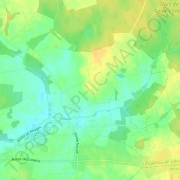
La Garde topographic map
Interactive map
Click on the map to display elevation.
About this map
Name: La Garde topographic map, elevation, terrain.
Average elevation: 106 m
Minimum elevation: 93 m
Maximum elevation: 117 m
Other topographic maps
Click on a map to view its topography, its elevation and its terrain.
Contres
France > Centre-Val de Loire > Loir-et-Cher > Le Controis-en-Sologne
Contres, Le Controis-en-Sologne, Romorantin-Lanthenay, Loir-et-Cher, Centre-Val de Loire, France métropolitaine, 41700, France
Average elevation: 107 m
Peraclos
France > Centre-Val de Loire > Loir-et-Cher > Le Controis-en-Sologne > Les Aunaux
Peraclos, Les Aunaux, Feings, Le Controis-en-Sologne, Romorantin-Lanthenay, Loir-et-Cher, Centre-Val de Loire, France métropolitaine, 41120, France
Average elevation: 95 m
Le Controis en Sologne
France > Centre-Val de Loire > Loir-et-Cher > Le Controis-en-Sologne
Le Controis en Sologne, Le Controis-en-Sologne, Romorantin-Lanthenay, Loir-et-Cher, Centre-Val de Loire, France métropolitaine, 41700, France
Average elevation: 104 m
Coulomme
France > Centre-Val de Loire > Loir-et-Cher > Le Controis-en-Sologne > Coulomnes
Coulomme, Coulomnes, Feings, Le Controis-en-Sologne, Romorantin-Lanthenay, Loir-et-Cher, Centre-Val de Loire, France métropolitaine, 41120, France
Average elevation: 93 m