
Ranni topographic map
Interactive map
Click on the map to display elevation.
About this map
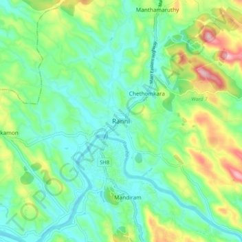
Name: Ranni topographic map, elevation, terrain.
Location: Ranni, Pattanamtitta, Kerala, India (9.34526 76.74488 9.42526 76.82488)
Average elevation: 66 m
Minimum elevation: 1 m
Maximum elevation: 222 m
Other topographic maps
Click on a map to view its topography, its elevation and its terrain.