
Municipality of Nemea topographic map
Interactive map
Click on the map to display elevation.
Municipality of Nemea
Nemea (altitude ca. 300m) is situated in a relatively plain basin surrounded by mountains, that reach ca. 750m.. The ancient town, Αρχαία Νεμέα, (at ca. 360m) is in a somewhat smaller basin to the east. Both basins empty through their own valley into the Gulf of Corinth. The surface of the two basins varies by only a few meters. The soil contains weathered elements of Limestone. The composition of the soil, the basin's geology, the altitude and the climate are ideal for viticulture.
About this map
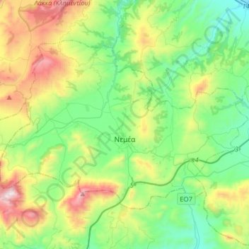
Name: Municipality of Nemea topographic map, elevation, terrain.
Average elevation: 461 m
Minimum elevation: 50 m
Maximum elevation: 1,410 m
Other topographic maps
Click on a map to view its topography, its elevation and its terrain.
Θροφάρι
Greece > Peloponnese, Western Greece and the Ionian > Corinthia Regional Unit > Municipal Unit of Xylokastro
Average elevation: 619 m
Kato Diminio Community
Greece > Peloponnese, Western Greece and the Ionian > Corinthia Regional Unit > Municipal Unit of Sikyona
Average elevation: 27 m
Kiato
Greece > Peloponnese, Western Greece and the Ionian > Corinthia Regional Unit > Municipal Unit of Sikyona
Average elevation: 32 m
Ζήρεια
Greece > Peloponnese, Western Greece and the Ionian > Corinthia Regional Unit > Municipal Unit of Xylokastro
Average elevation: 1,561 m
Ρίζα
Greece > Peloponnese, Western Greece and the Ionian > Corinthia Regional Unit > Municipal Unit of Xylokastro
Average elevation: 253 m
Municipal Unit of Vocha
Greece > Peloponnese, Western Greece and the Ionian > Corinthia Regional Unit
Average elevation: 203 m
Ancient Korinthos
Greece > Peloponnese, Western Greece and the Ionian > Corinthia Regional Unit > Municipal Unit of Corinth
Average elevation: 101 m
Municipal Unit of Velos
Greece > Peloponnese, Western Greece and the Ionian > Corinthia Regional Unit
Average elevation: 276 m
Velo
Greece > Peloponnese, Western Greece and the Ionian > Corinthia Regional Unit > Municipal Unit of Velos
Average elevation: 50 m
Municipal Unit of Loutraki - Perachora
Greece > Peloponnese, Western Greece and the Ionian > Corinthia Regional Unit
Average elevation: 170 m
Municipal Unit of Sikyona
Greece > Peloponnese, Western Greece and the Ionian > Corinthia Regional Unit
Average elevation: 478 m
Corinth
Greece > Peloponnese, Western Greece and the Ionian > Corinthia Regional Unit
Average elevation: 185 m