
Make a donation
Gear up for your next adventure:
As an Amazon Associate, this site earns from qualifying purchases at no extra cost to you.
Tarna Mare topographic map
Click on the map to display elevation.
Make a donation
Gear up for your next adventure:
As an Amazon Associate, this site earns from qualifying purchases at no extra cost to you.
Tarna Mare
Tarna Mare is situated in the Țara Oașului ethnocultural and historical region in the extreme north of Satu Mare County. It lies at an altitude of 168 m (551 ft), on the banks of the river Tarna Mare. The commune is located 54 km (34 mi) northeast of the county seat, Satu Mare, on the border with Ukraine.
Make a donation
Gear up for your next adventure:
As an Amazon Associate, this site earns from qualifying purchases at no extra cost to you.
About this map
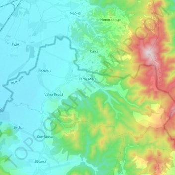
Name: Tarna Mare topographic map, elevation, terrain.
Location: Tarna Mare, Satu Mare, Romania (48.05114 23.11385 48.12000 23.29102)
Average elevation: 292 m
Minimum elevation: 127 m
Maximum elevation: 829 m
Make a donation
Gear up for your next adventure:
As an Amazon Associate, this site earns from qualifying purchases at no extra cost to you.
Other topographic maps
Click on a map to view its topography, its elevation and its terrain.
Make a donation
Gear up for your next adventure:
As an Amazon Associate, this site earns from qualifying purchases at no extra cost to you.