
Κρηνίδες topographic map
Interactive map
Click on the map to display elevation.
About this map
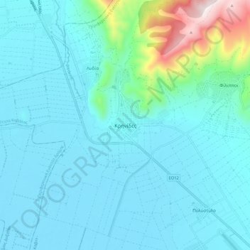
Name: Κρηνίδες topographic map, elevation, terrain.
Average elevation: 142 m
Minimum elevation: 40 m
Maximum elevation: 797 m
Other topographic maps
Click on a map to view its topography, its elevation and its terrain.
Χρυσούπολη
Griekenland > Macedonië - Thracië > Περιφερειακή Ενότητα Καβάλας
Χρυσούπολη, Δήμος Νέστου, Περιφερειακή Ενότητα Καβάλας, Oost-Macedonië en Thracië, Macedonië - Thracië, 642 00, Griekenland
Average elevation: 22 m