
Thank you for supporting this site ❤️
Make a donation
Make a donation
Gear up for your next adventure:
As an Amazon Associate, this site earns from qualifying purchases at no extra cost to you.
Espot topographic map
Click on the map to display elevation.
Thank you for supporting this site ❤️
Make a donation
Make a donation
Gear up for your next adventure:
As an Amazon Associate, this site earns from qualifying purchases at no extra cost to you.
About this map
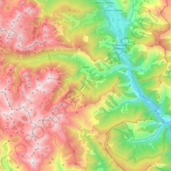
Name: Espot topographic map, elevation, terrain.
Location: Espot, Pallars Sobirà, Lleida, Catalonia, Spain (42.50877 0.93720 42.61015 1.14621)
Average elevation: 1,867 m
Minimum elevation: 848 m
Maximum elevation: 2,926 m
Thank you for supporting this site ❤️
Make a donation
Make a donation
Gear up for your next adventure:
As an Amazon Associate, this site earns from qualifying purchases at no extra cost to you.
Other topographic maps
Click on a map to view its topography, its elevation and its terrain.
Gerri de la Sal
Spain > Catalonia > Pallars Sobirà > Baix Pallars > Gerri de la Sal
Average elevation: 833 m