
Christmas Island topographic map
Interactive map
Click on the map to display elevation.
About this map
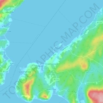
Name: Christmas Island topographic map, elevation, terrain.
Average elevation: 25 m
Minimum elevation: -5 m
Maximum elevation: 191 m
Other topographic maps
Click on a map to view its topography, its elevation and its terrain.
O'Neils Point
Kanada > Neuschottland > Cape Breton Regional Municipality > Glace Bay
O'Neils Point, Glace Bay, Cape Breton Regional Municipality, Cape Breton County, Neuschottland, B1A 6E9, Kanada
Average elevation: 8 m