
Kalawana topographic map
Interactive map
Click on the map to display elevation.
About this map
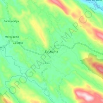
Name: Kalawana topographic map, elevation, terrain.
Location: Kalawana, Ratnapura District, Sabaragamuwa Province, Sri Lanka (6.49109 80.35648 6.57109 80.43648)
Average elevation: 316 m
Minimum elevation: 104 m
Maximum elevation: 742 m
Other topographic maps
Click on a map to view its topography, its elevation and its terrain.
Sinharaja Forest Reserve
Sri Lanka > Sabaragamuwa Province > Palinda-Nuwara (Baduraliya) DS Division
Average elevation: 374 m
Sinharaja Forest Reserve
Sri Lanka > Sabaragamuwa Province > Palinda-Nuwara (Baduraliya) DS Division
Average elevation: 374 m