Geolocate

Spry topographic map

Click on the map to display elevation.

About this map

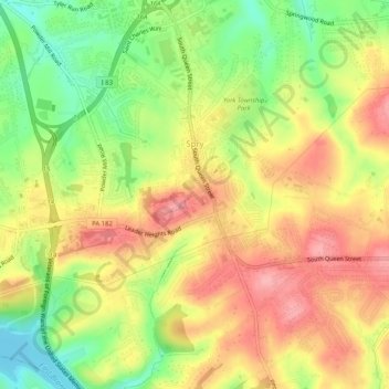
Name: Spry topographic map, elevation, terrain.

Location: Spry, York Township, York County, Pennsylvania, United States (39.89371 -76.70479 39.93280 -76.66180)

Average elevation: 206 m

Minimum elevation: 146 m

Maximum elevation: 257 m

Other topographic maps

Click on a map to view its topography, its elevation and its terrain.

Arbor

United States > Pennsylvania > York County > York Township

Average elevation: 244 m

Gear up for your next adventure:

👖Convertible Hiking Trousers - Versatile zip-off pants for changing mountain weather conditions
🐕Dog Hiking Gear - Equipment for hiking safely with dogs
🎒Backpack Rain Covers - Universal waterproof covers to protect your gear from downpours
🛰️Handheld GPS Devices - Reliable GPS units for hiking and outdoor navigation
🧊Insulated Flasks - Keeps drinks hot or cold during hikes

As an Amazon Associate, this site earns from qualifying purchases at no extra cost to you.