
Ciudad del Sol topographic map
Interactive map
Click on the map to display elevation.
About this map
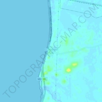
Name: Ciudad del Sol topographic map, elevation, terrain.
Location: Ciudad del Sol, Champotón, Campeche, México (19.45791 -90.72234 19.49791 -90.68234)
Average elevation: 1 m
Minimum elevation: -3 m
Maximum elevation: 23 m
Other topographic maps
Click on a map to view its topography, its elevation and its terrain.
López Portillo
México > Campeche > Champotón > Valle de Quetzalcóatl
López Portillo, Valle de Quetzalcóatl, Champotón, Campeche, México
Average elevation: 23 m
San Juan Carpizo
México > Campeche > Champotón > San Juan Carpizo
San Juan Carpizo, Champotón, Campeche, 24423, México
Average elevation: 14 m