
Obermumpf topographic map
Interactive map
Click on the map to display elevation.
About this map
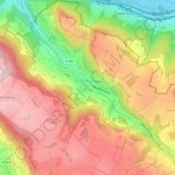
Name: Obermumpf topographic map, elevation, terrain.
Location: Obermumpf, Bezirk Rheinfelden, Aargau, 4324, Schweiz (47.51324 7.91656 47.54313 7.95658)
Average elevation: 466 m
Minimum elevation: 298 m
Maximum elevation: 587 m
Other topographic maps
Click on a map to view its topography, its elevation and its terrain.
Möhlin
Schweiz > Aargau > Bezirk Rheinfelden
Möhlin, Bezirk Rheinfelden, Aargau, 4313, Schweiz
Average elevation: 334 m
Rheinfelden
Schweiz > Aargau > Bezirk Rheinfelden
Rheinfelden, Bezirk Rheinfelden, Aargau, 4310, Schweiz
Average elevation: 319 m