
Make a donation
Gear up for your next adventure:
As an Amazon Associate, this site earns from qualifying purchases at no extra cost to you.
Nutley topographic map
Click on the map to display elevation.
Make a donation
Gear up for your next adventure:
As an Amazon Associate, this site earns from qualifying purchases at no extra cost to you.
About this map
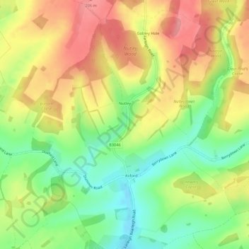
Name: Nutley topographic map, elevation, terrain.
Average elevation: 156 m
Minimum elevation: 104 m
Maximum elevation: 208 m
Hampshire trails, hiking, mountain biking, running and outdoor activities
Make a donation
Gear up for your next adventure:
As an Amazon Associate, this site earns from qualifying purchases at no extra cost to you.
Other topographic maps
Click on a map to view its topography, its elevation and its terrain.
Basingstoke
United Kingdom > England > Hampshire > Basingstoke and Deane
Situated in a valley through the Hampshire Downs at an average elevation of 88 metres (289 ft) Basingstoke is a major interchange between Reading, Newbury, Andover, Winchester, and Alton, and lies on the natural trade route between the southwest of England and London. The area had been something of an…
Average elevation: 109 m
Basingstoke
United Kingdom > England > Hampshire > Basingstoke and Deane
Situated in a valley through the Hampshire Downs at an average elevation of 88 metres (289 ft) Basingstoke is a major interchange between Reading, Newbury, Andover, Winchester, and Alton, and lies on the natural trade route between the southwest of England and London. The area had been something of an…
Average elevation: 107 m
Morgaston Wood
United Kingdom > England > Hampshire > Basingstoke and Deane > Sherborne St John
Average elevation: 76 m
Make a donation
Gear up for your next adventure:
As an Amazon Associate, this site earns from qualifying purchases at no extra cost to you.
Sherborne St John
United Kingdom > England > Hampshire > Basingstoke and Deane
Average elevation: 92 m
Highclere Castle
United Kingdom > England > Hampshire > Basingstoke and Deane
Average elevation: 166 m
Make a donation
Gear up for your next adventure:
As an Amazon Associate, this site earns from qualifying purchases at no extra cost to you.
Bramley Corner
United Kingdom > England > Hampshire > Basingstoke and Deane > Bramley
Average elevation: 69 m
Make a donation
Gear up for your next adventure:
As an Amazon Associate, this site earns from qualifying purchases at no extra cost to you.
Make a donation
Gear up for your next adventure:
As an Amazon Associate, this site earns from qualifying purchases at no extra cost to you.
Pamber Green
United Kingdom > England > Hampshire > Basingstoke and Deane > Tadley
Average elevation: 85 m
Wolverton Townsend
United Kingdom > England > Hampshire > Basingstoke and Deane
Average elevation: 106 m
Cufaude
United Kingdom > England > Hampshire > Basingstoke and Deane > Bramley
Average elevation: 69 m
Make a donation
Gear up for your next adventure:
As an Amazon Associate, this site earns from qualifying purchases at no extra cost to you.
River Lyde
United Kingdom > England > Hampshire > Basingstoke and Deane > Up Nately
Average elevation: 78 m
Cole Henley
United Kingdom > England > Hampshire > Basingstoke and Deane > Whitchurch
Average elevation: 118 m
Latchmere Green
United Kingdom > England > Hampshire > Basingstoke and Deane > Little London > Latchmere Green
Average elevation: 73 m
Make a donation
Gear up for your next adventure:
As an Amazon Associate, this site earns from qualifying purchases at no extra cost to you.
Heath End
United Kingdom > England > Hampshire > Basingstoke and Deane > East End > Heath End
Average elevation: 144 m
Chilton Candover
United Kingdom > England > Hampshire > Basingstoke and Deane > Chilton Candover
Average elevation: 118 m
Make a donation
Gear up for your next adventure:
As an Amazon Associate, this site earns from qualifying purchases at no extra cost to you.
Tufton
United Kingdom > England > Hampshire > Basingstoke and Deane > Hurstbourne Priors
Average elevation: 87 m
Ellisfield Green
United Kingdom > England > Hampshire > Basingstoke and Deane > Ellisfield
Average elevation: 175 m
Make a donation
Gear up for your next adventure:
As an Amazon Associate, this site earns from qualifying purchases at no extra cost to you.
Bidden
United Kingdom > England > Hampshire > Basingstoke and Deane > Upton Grey
Average elevation: 107 m
Basingstoke
United Kingdom > England > Hampshire > Basingstoke and Deane
Situated in a valley through the Hampshire Downs at an average elevation of 88 metres (289 ft), Basingstoke is a major interchange between Reading, Newbury, Andover, Winchester and Alton. It lies on the natural trade route between the south-west of England and London. The area had been something of an…
Average elevation: 107 m
Make a donation
Gear up for your next adventure:
As an Amazon Associate, this site earns from qualifying purchases at no extra cost to you.
Basingstoke
United Kingdom > England > Hampshire > Basingstoke and Deane
Situated in a valley through the Hampshire Downs at an average elevation of 88 metres (289 ft) Basingstoke is a major interchange between Reading, Newbury, Andover, Winchester, and Alton, and lies on the natural trade route between the southwest of England and London. The area had been something of an…
Average elevation: 107 m
Basingstoke
United Kingdom > England > Hampshire > Basingstoke and Deane
Situated in a valley through the Hampshire Downs at an average elevation of 88 metres (289 ft), Basingstoke is a major interchange between Reading, Newbury, Andover, Winchester and Alton. It lies on the natural trade route between the south-west of England and London. The area had been something of an…
Average elevation: 107 m
Make a donation
Gear up for your next adventure:
As an Amazon Associate, this site earns from qualifying purchases at no extra cost to you.