
Geghard topographic map
Interactive map
Click on the map to display elevation.
About this map
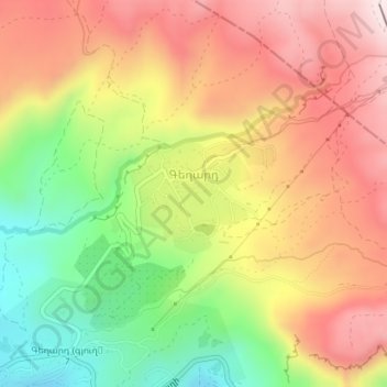
Name: Geghard topographic map, elevation, terrain.
Location: Geghard, Garni Region, Kotayk Province, Armenia (40.15104 44.79218 40.15947 44.80712)
Average elevation: 1,930 m
Minimum elevation: 1,665 m
Maximum elevation: 2,161 m
Other topographic maps
Click on a map to view its topography, its elevation and its terrain.
Hrazdan
Armenia > Kotayk Province > Hrazdan
Hrazdan has an average elevation of 1,675 meters above sea level. The town has a warm-summer humid continental climate (Köppen climate classification Dfb).The average temperature is 6 °C (ranging from -7 °C in January to 18.1 °C in August). The annual precipitation is around 700 mm.
Average elevation: 1,825 m