
Make a donation
Gear up for your next adventure:
As an Amazon Associate, this site earns from qualifying purchases at no extra cost to you.
Ribicioara topographic map
Click on the map to display elevation.
Make a donation
Gear up for your next adventure:
As an Amazon Associate, this site earns from qualifying purchases at no extra cost to you.
About this map
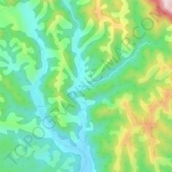
Name: Ribicioara topographic map, elevation, terrain.
Location: Ribicioara, Ribița, Hunedoara, 337404, Romania (46.19073 22.75636 46.23073 22.79636)
Average elevation: 407 m
Minimum elevation: 270 m
Maximum elevation: 702 m
Make a donation
Gear up for your next adventure:
As an Amazon Associate, this site earns from qualifying purchases at no extra cost to you.
Other topographic maps
Click on a map to view its topography, its elevation and its terrain.
Bucura Lake
Romania > Hunedoara > Râu de Mori
Lake Bucura is a glacier cirque lake, situated in the Retezat Mountains, in Romania. It is located south of the main ridge, at the base of Peleaga Peak, and at an altitude of about 2,040 m.
Average elevation: 2,137 m
Make a donation
Gear up for your next adventure:
As an Amazon Associate, this site earns from qualifying purchases at no extra cost to you.
Make a donation
Gear up for your next adventure:
As an Amazon Associate, this site earns from qualifying purchases at no extra cost to you.
Make a donation
Gear up for your next adventure:
As an Amazon Associate, this site earns from qualifying purchases at no extra cost to you.
Make a donation
Gear up for your next adventure:
As an Amazon Associate, this site earns from qualifying purchases at no extra cost to you.
Bătrâna
Bătrâna is located in the western part of Hunedoara County, about 53 km (33 mi) southwest of the county seat, Deva, on the border with Timiș County. It is situated in a mountainous landscape north of the Poiana Ruscă Mountains, at an altitude of 960 m (3,150 ft). The river Ciorman flows through the…
Average elevation: 695 m
Make a donation
Gear up for your next adventure:
As an Amazon Associate, this site earns from qualifying purchases at no extra cost to you.
Make a donation
Gear up for your next adventure:
As an Amazon Associate, this site earns from qualifying purchases at no extra cost to you.
Make a donation
Gear up for your next adventure:
As an Amazon Associate, this site earns from qualifying purchases at no extra cost to you.
Make a donation
Gear up for your next adventure:
As an Amazon Associate, this site earns from qualifying purchases at no extra cost to you.
Make a donation
Gear up for your next adventure:
As an Amazon Associate, this site earns from qualifying purchases at no extra cost to you.