Geolocate

Victor topographic map

Click on the map to display elevation.

About this map

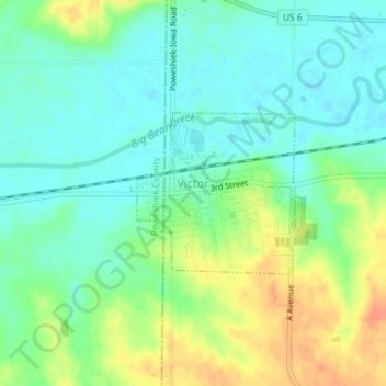
Name: Victor topographic map, elevation, terrain.

Location: Victor, Iowa County, Iowa, United States (41.72502 -92.30324 41.73634 -92.28837)

Average elevation: 254 m

Minimum elevation: 238 m

Maximum elevation: 283 m

Other topographic maps

Click on a map to view its topography, its elevation and its terrain.

Amana

United States > Iowa > Iowa County

Average elevation: 222 m

Gear up for your next adventure:

Lightweight Tents - Compact tents for backpacking and trekking
🥫Expedition Meals - Lightweight, high-calorie nutrition for long-distance hikers
🗺️Scratch-off Peak Maps - Track your progress climbing Munros or Wainwrights
🧊Insulated Flasks - Keeps drinks hot or cold during hikes
🌄Compact Monoculars - Lightweight optics for hiking

As an Amazon Associate, this site earns from qualifying purchases at no extra cost to you.