
Θεολόγος topographic map
Interactive map
Click on the map to display elevation.
About this map
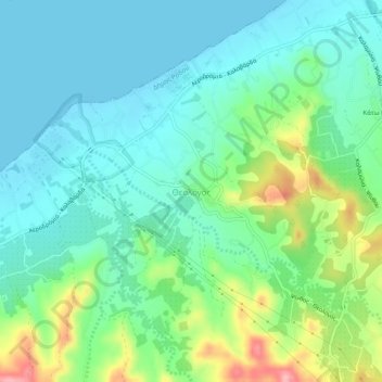
Name: Θεολόγος topographic map, elevation, terrain.
Average elevation: 36 m
Minimum elevation: -2 m
Maximum elevation: 137 m
Other topographic maps
Click on a map to view its topography, its elevation and its terrain.
Δήμος Σύμης
Griekenland > Egeïsche Eilanden > Rhodos
Δήμος Σύμης, Rhodos, Zuid-Egeïsche Eilanden, Egeïsche Eilanden, 856 00, Griekenland
Average elevation: 42 m
Λίνδος
Griekenland > Egeïsche Eilanden > Rhodos > Λίνδος
Λίνδος, Ακροπολεως, Λίνδος, Δήμος Ρόδου, Rhodos, Zuid-Egeïsche Eilanden, Egeïsche Eilanden, 851 07, Griekenland
Average elevation: 46 m