
Make a donation
Gear up for your next adventure:
As an Amazon Associate, this site earns from qualifying purchases at no extra cost to you.
Nisutlin River topographic map
Click on the map to display elevation.
Make a donation
Gear up for your next adventure:
As an Amazon Associate, this site earns from qualifying purchases at no extra cost to you.
About this map
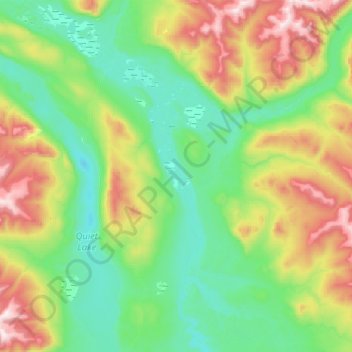
Name: Nisutlin River topographic map, elevation, terrain.
Location: Nisutlin River, Yukon, Canada (61.00000 -132.98349 61.25000 -132.64568)
Average elevation: 1,011 m
Minimum elevation: 732 m
Maximum elevation: 1,763 m
Make a donation
Gear up for your next adventure:
As an Amazon Associate, this site earns from qualifying purchases at no extra cost to you.
Other topographic maps
Click on a map to view its topography, its elevation and its terrain.
Whitehorse
Whitehorse has a subarctic climate (Köppen climate classification: Dfc) and lies in the rain shadow of the Coast Mountains, causing precipitation totals to be quite low year-round. Due to the city's location in the Whitehorse valley, the climate is milder than other comparable northern communities such as…
Average elevation: 1,008 m
Make a donation
Gear up for your next adventure:
As an Amazon Associate, this site earns from qualifying purchases at no extra cost to you.