
Ait Taguella topographic map
Interactive map
Click on the map to display elevation.
About this map
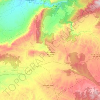
Name: Ait Taguella topographic map, elevation, terrain.
Average elevation: 1,092 m
Minimum elevation: 529 m
Maximum elevation: 1,677 m
Other topographic maps
Click on a map to view its topography, its elevation and its terrain.
Cascades d'Ouzoud
Maroc > Béni Mellal-Khénifra > Ait Taguella
Cascades d'Ouzoud, Ait Taguella, caïdat de Tanant, cercle de Bzou, Province d'Azilal, Béni Mellal-Khénifra, Maroc
Average elevation: 781 m