Geolocate

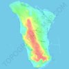
Kharg topographic map

Click on the map to display elevation.

About this map

Name: Kharg topographic map, elevation, terrain.

Location: Kharg, جزیره خارک, بخش خارگ, Bushehr County, Bushehr Province, Iran (29.20522 50.27170 29.28522 50.35170)

Average elevation: 8 m

Minimum elevation: -4 m

Maximum elevation: 81 m

Other topographic maps

Click on a map to view its topography, its elevation and its terrain.
Gear up for your next adventure:

👟Men's Trail Running Shoes - Lightweight grip for fast movement over topographic contours
🩹Hiking First Aid Kits - Compact medical kits tailored for trail injuries and emergencies
🥾Walking Shoes - Lightweight walking shoes for countryside and coastal paths
💧Hydration Reservoirs - Convenient water bladders for hands-free drinking on the move
🧥Softshell Jackets - Breathable jackets for active outdoor use

As an Amazon Associate, this site earns from qualifying purchases at no extra cost to you.